PROGRESS REPORTING SERVICES
Track Every Stage of Your Project with Regularly Updated Surveys, Digital Plans, and Models for Complete Visibility.
When working with us
YOU CAN EXPECT
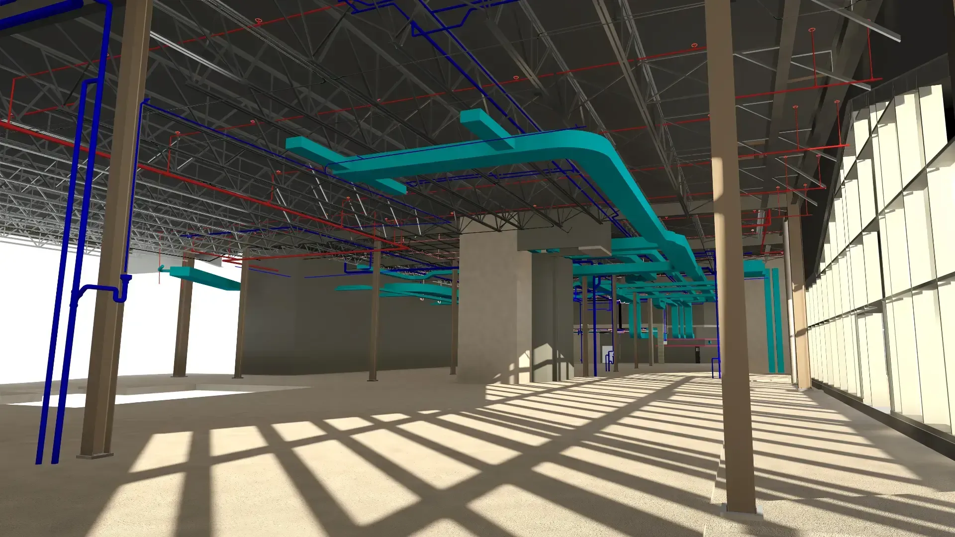
We transform your physical spaces into high-quality digital plans and models and deliver them at key stages of your project to ensure thorough progress reporting. By combining advanced LiDAR scanning technology with our drafting expertise, we provide accurate and reliable data you can use with confidence throughout your project.
PRECISION
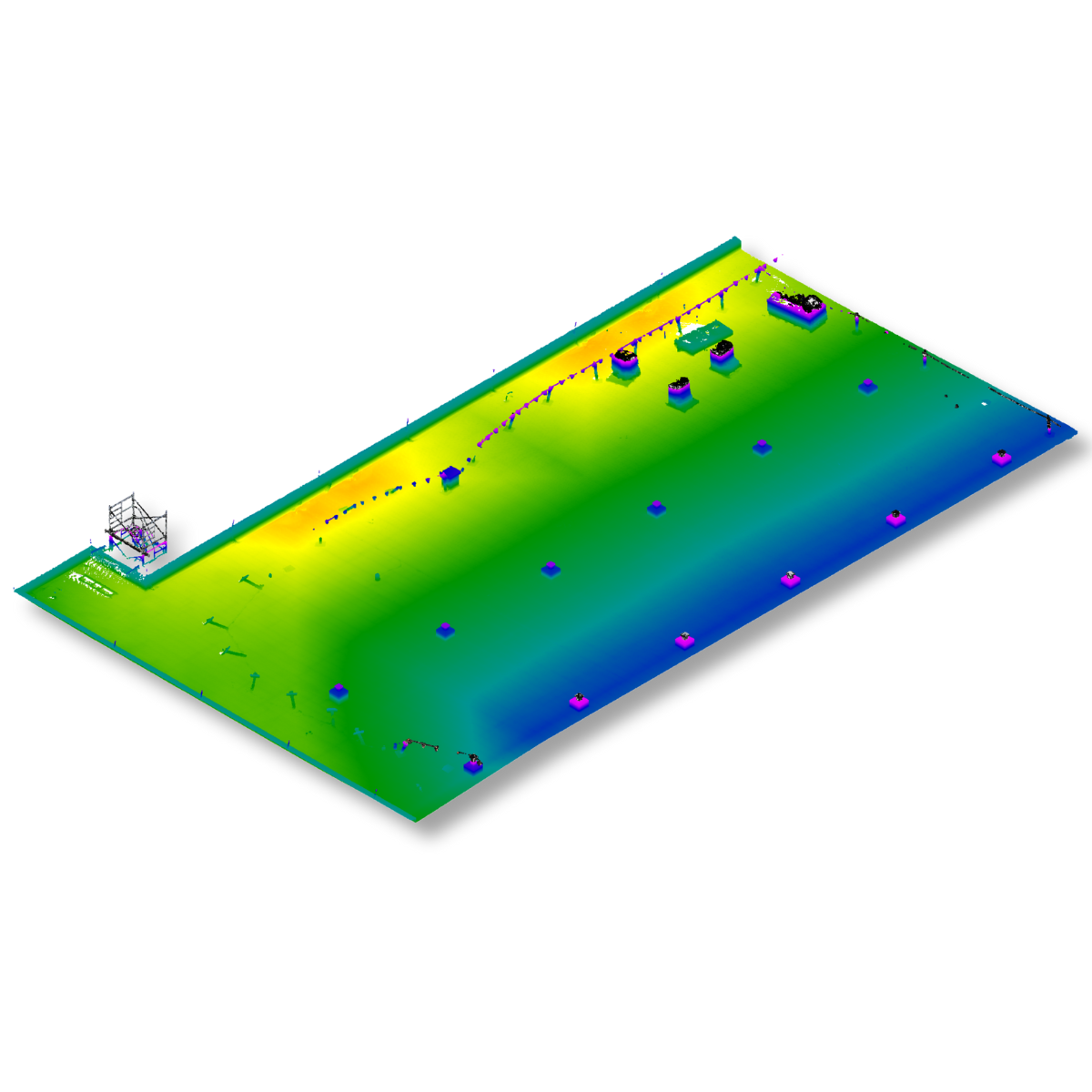
Our progress reporting services start with detailed on-site data capture, documenting every dimension and feature of your building or equipment. This precise foundation enables highly accurate as-built plans, reports and 3D models that reflect real-world conditions, reducing errors during design, renovation, or construction.
FIELD TO FILE
We capture and convert spatial data into clean, structured as-built plans, reports and 3D models. Deliverables are provided in the format of your choice, including DWG, Revit, CAD, STEP, SAT, and more, making them easy to integrate into your workflow.
EFFICIENCY
With accurate and reliable as-built plans, reports and 3D models, you can focus on what matters most. Our progress reporting services help you track your project’s progress, minimize errors caused by data inaccuracies, and improve efficiency.
Proven results across 400+ projects
We work with clients across various sectors, including construction, architecture, and manufacturing. Our goal is to provide high-quality progress reporting services perfectly tailored to your needs.

FAQ
Want to learn more about our 3D scanning, 3D modeling and progress reporting services? Our team is here to answer your questions and provide personalized guidance. Feel free to contact us to discuss your project.
What is included in your progress reports?
Our progress reports offer a comprehensive view of your project at key milestones. Each report can include high-quality 2D plans, detailed 3D models, and reports. These deliverables allow you to track project advancements, identify potential issues, and gain a clear understanding of current conditions. Our goal is to provide precise, actionable information that supports architects, engineers, and project managers in making informed decisions.
How often are progress reports provided?
We deliver progress reports according to a schedule tailored to your needs, ensuring you receive updates exactly when you need them. This approach guarantees that you always have up-to-date insights throughout your project. Each update provides a clear and comprehensive picture of your project’s current status, helping you track progress and make informed decisions.
How accurate are the data and deliverables?
We use LiDAR scanners with millimeter-level accuracy to capture precise measurements, ensuring our data, as-built plans, reports and 3D models are highly accurate. While absolute millimetric precision cannot be guaranteed, our 3D models, as-built plans and reports consistently deliver a very high level of accuracy, making them ideal for design, planning, and construction applications.
What is your 3D scanning process?
Our 3D data capture process typically involves several key steps. First, we select the most suitable tool for the project. The site is then scanned from multiple angles to cover its entire surface and generate a point cloud. These raw data are processed using specialized software for alignment, cleaning, and merging, resulting in 3D models, detailed plans, or building analyses.
The final outputs can include 3D models, BIM (Building Information Modeling) models with detailed component data, architectural or technical plans, and building analyses such as BOMA measurements, flatness and verticality studies, or structural deformation assessments. All outputs are based on our precise surveys, providing a reliable foundation for planning, maintenance, and renovations.
Our laser scanners provide real-time visual feedback during capture, allowing us to verify that every area has been fully documented. In simple terms, we capture the environment in 3D the same way a camera captures photographs and then process the data to rebuild an accurate digital version of the existing conditions.
For more information about our 3D scanning and modeling process, you can explore these articles:
Which deliverable formats do you offer, and do you provide training?
We deliver as-built plans, reports and 3D models in the format of your choice, including DWG, Revit, CAD, STEP, SAT, and more. Personalized training is also available to help you use your new plans or models effectively and get the most out of your digital files.
"A high-quality, fast, and efficient service."
- Juliano Rodriguez-Daoust,
VP Business Development and Acquisitions
Carrossielli Group